New Wonders Await Adventure Seekers
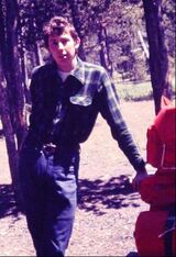 Joe Cartwright Joe Cartwright
By JOE CARTWRIGHT
Special to North Palm Beach Life Photos by Joe Cartwright Yellowstone National Park has, for most of my life, been my favorite place to relax, sightsee, hike, and just in general, unwind. However, my favorite areas in Yellowstone are those out-of-the-way, little-known destinations bypassed by the usual Yellowstone visitor. I do love geyser-watching, photographing and watching the wildlife, just like the typical tourist; but anyone who thinks that Yellowstone is crowded should try to get a little more off the beaten path. They will be rewarded with a new Yellowstone, mostly located just a few hundred yards from the most popular sights. Most of the Unknown Yellowstone attractions require some hiking, but some are drivable. On a recent visit, we entered Yellowstone through the least-used entrance: The southwest entrance. In order to get to this entrance, you have to go into Idaho and come in through Forest Service roads. To clear up any confusion, most of Yellowstone National Park is in Wyoming, but portions of it overlap into Montana and Idaho. The southwest entrance leads into two primary features: Cave Falls and Bechler Ranger Station. Cave Falls probably qualifies as Yellowstone’s least-visited waterfall that you don’t have to hike to. Bechler Ranger Station is also a starting spot for many of southeast Yellowstone’s trails. An old dirt road leads five miles from the Mammoth Hot Springs area into Gardiner – the small Montana town at the North Entrance of Yellowstone. This old dirt road is a one-way road going northbound and travels high above the main highway. It passes over the 45th parallel, which is the Wyoming/Montana border. The 45th parallel is also notable as the halfway point between the Equator and the North Pole. Since this dirt road is so infrequently traveled, it is also a very good place to see wildlife: Especially pronghorn (antelope), elk and deer. Plan on averaging less than 15 – 20 mph on this occasionally very rough road. Allow at least 30 minutes for one trip. Also in the Park’s northern section, the Blacktail Plateau Road is another scenic dirt road paralleling the main highway. It is six miles of dirt, dust and washboard surface. For many years, the road followed a pleasant, mostly wooded route one way alongside the Grand Loop Road. Forest fires, mainly those in 1988, decimated the forests that used to shade this road. Once, I photographed – from a long, safe distance – a mother grizzly and her cub at a pullout on this road. When I was working summers in Yellowstone, I had the opportunity to explore much of Yellowstone on both long and short trails. Although I only had one day a week off, I could sometimes angle my work shift to give me maximum hiking time. Also, some short trails can be hiked during a morning off, or an afternoon off. I did the best I could to push my distance limits, and was rewarded with a view of Yellowstone that not many others experienced. |
INDEXHeart Lake/Mt. Sheridan
Heart Lake has been one of my favorite medium-hike destinations for years. This back country lake covers about 2100 acres of Yellowstone wilderness. Summit Lake/Smokejumper Hot Springs This trail was a hard one to find, at first. For some time I had wanted to hike to this seldom-visited lake near the Continental Divide. Shoshone Lake At over 8,000 acres, Shoshone Lake is the largest wilderness lake in the lower 48 states that does not have a road reaching it. Grizzly Lake This trail is a fun, relatively short trail leading to a beautiful back country lake. Riddle Lake Riddle Lake is just north of Heart Lake, and it is a short hike: only 2½ miles long. Pelican Cone For many years, I had heard about the trail to the Pelican Cone Fire Lookout. Mt. Washburn The Mount Washburn hike is a very unusual trail for Yellowstone. Specimen Ridge Yellowstone has had major eruptions at least three times in the past, and each eruption buried trees and other plant life beneath rock and ash. Avalanche Peak This trail is also best done as a ranger-led hike. Divide Creek The Divide Creek trail used to lead to the Divide Creek fire lookout tower – an 80-foot tall tower with a cabin on top. About the Photos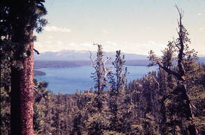
The majority of the photos are from slides that were scanned in 2004. The original photos were taken with a Pentax Spotmatic, primarily with a Pentax 50mm f1.4 lens.; occasionally a 28mm Vivitar f2.5 was used. The 2007 photos were shot with a Canon EOS Digital Rebel XTi (also known as EOS 400D -- same camera, two names) with a Canon 18-55mm zoom lens.
|